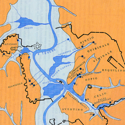
Geological Map of the Roman Countryside. Ponzi, G., 1880
Ponzi, G. (1880) Carta geologica della Campagna Romana con Sezioni.

This beautiful map has a breadth and clarity that makes the relationship of the city or Rome to its geological context immediately apparent. It is possible to quickly read the different rock types, the topography, and the carving force of the Tiber River. The city of Rome is visible at the confluence of the section lines, located at the midpoint between the two volcanos.
Of course, there are more recent maps of Rome’s geology available. They are more accurate and much more detailed, with a profusion of rock types and classifications that result in a proliferation of colors, hatches and line types. These maps are amazing when precision is required, but such detail can obscure the big picture. Early geologic maps help to understand the structure of the territory and its formation. The moment of discovery and of representation before a drawing language is codified can be very useful for designers.